Yosemite National Park is the crown jewel of US national parks. We had great three days at the park. The real highlight of the visit was the the 7 hour hike to the Vernon falls and the Nevada Falls for the climb of 2300 ft The hike was little strenuous but very gratifying and spirit-lifting.
Yosemite Valley
This is the place people are usually thinking of when they think about
Yosemite. Many of the things Yosemite is famous for are here: El Capitan
and
Half Dome, Yosemite and
Bridalveil Falls, the Mist Trail, the
tunnel view.
Yosemite Valley is a freak of nature. It's only seven miles long and less than a mile wide, but it ranks higher in scenery per square foot than perhaps a hnywhere else in the world.
ecause it was formed by glaciation, the valley walls are sheer and high, leading to world-famous cliffs: El Capitan, a mountain-climbing mecca, rises more than 3,000 feet (900 meters) virtually straight up from the Yosemite Valley floor, and Half Dome looms 4,800 feet (1,600) meters above. Some of these pictures are covered during the album dedicated to sunrise and sunset.
We were fortunate enough to get the accomodation in side the park at the yosemite lodge.
Although Yosemite Valley is most famous for the walls that surround it, the valley floor itself is also very pretty.
The Merced River wanders through it, and meadows appear frequently along its length. Deer and coyotes
are common sights, and bear are known to be about after dark. Most of the places is covered in the Sunrise and sunset album,
We had some sighting of bears, Coyote, beautiful birds and plenty of deers. covered in the Yosemite Wildlife Album.
Hike to Vernon Falls and Nevada Falls
Yosemite Valley Highlights
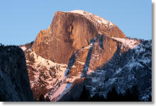 Half Dome |
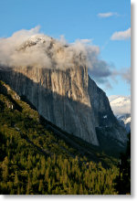 El Capitan |
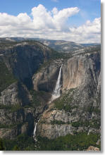 Yosemite Falls |
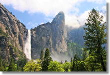 Bridalveil Fall |
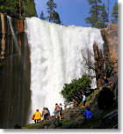 Vernal Fall |
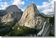 Nevada Fall |
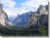 The Tunnel View |
 The Ahwahnee Hotel |
 Gates of the Valley |
Yosemite park beyond Valley
Yosemite Valley is the place people tare usually thinking of when they thinks of Yosemite,
What's the good of a breathtaking view if you're already out of breath? It's hard to enjoy yourself when
you're so worked that you're setting off other people's heart monitors.
There's something to be said for journeys that yield up their treasures easily, so for the pleasure
of scenery cognoscenti everywhere, here are the Yosemite hikes most apt to
keep your quality-of-life meters running solidly in the red:
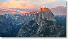
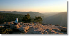
The views here are almost indescribable. There's a 270-degree panorama including Half Dome,
Clouds Rest, the waterfalls of the Mist Trail, dozens of peaks in the eastern Sierra range, and much of
Yosemite Valley. It's probably the best place in all of Yosemite for watching the sunset.
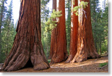
2. Lower Mariposa Grove (2.2 miles/3.5 km
round trip):
This hike is at the outer bounds of the easy category, since it
involves some ascent, but it's well worth it. It includes the
Grizzly Giant, which is not only the world's oldest sequoia, at 2,700
years, but also one of the world's largest living things;
the California Tunnel Tree, which you can walk through; the Bachelor
and Three Graces
(pictured here); and a variety of other behemoths that
would merit their own parks anywhere else in the world but don't even
rate their own names here.
3. Tuolumne Meadows (2 miles/3.2 km
round trip):
There's no place like a meadow for chilling out, and this one is
Yosemite's best. Just meander around the trails and soak up the sun
(it feels good when you're at 8,500 feet/2,550 meters elevation) and
enjoy the wildflowers and the river and the deer and the granite peaks
surrounding the meadow.
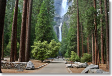
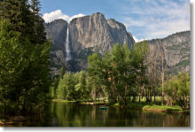
4. Lower Yosemite Falls (0.5 miles/0.8 km
round trip):
Hike to the base of the tallest waterfall in North America and absorb
some of the adrenaline-soaked spray that's just
survived a 2,400-foot (720-meter) freefall. Best in the spring and
early summer, when there's lots of water roaring over the falls.
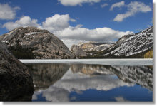
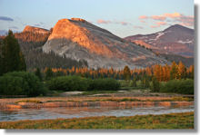
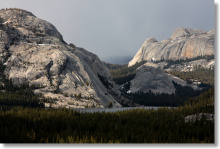
5. Tenaya Lake (2.5 mile/4 km
loop):
If you've ever wanted to step into a postcard, come to Tenaya Lake. The
lake is beautiful enough by itself, but it's also got beaches
along the eastern and western shores and is surrounded by striking
granite domes and peaks.
6. Sentinel Dome (2.2 miles/3.5 km round trip):
Sentinel Dome is at the upper end of the easy category, due to the
short but steep foray up the side of the dome to the summit.
Once there, though, you'll find 360 degrees of view encompassing
Yosemite Valley, the high Sierras, and
(on unusually clear days) the coastal range.
7. Bridalveil Fall (1.2 miles/1.9 km
round trip):
A short walk to the base of this 620-foot (189-meter) waterfall that's
one of the most famous in the world, photographed millions of times from
Yosemite's
tunnel view.
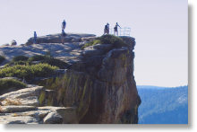
8. Taft Point (2.2 miles/3.5 km
round trip):
Heart-starting views over the very sheer edge of the south rim of Yosemite Valley,
with only the most basic of guardrails to hold you up. After you've
driven to Yosemite Valley and gotten out of your car to look at El
Capitan
just because it's too tall to see the top of through your windshield,
hike to Taft Point so you can look down on it instead.
9. Sentinel & Cook's Meadow Loop (2.25 miles/3.6 km round trip):
This nearly flat hike takes you through two meadows in the heart of Yosemite Valley, crosses the Merced River twice -
including a trip over the iconic Swinging Bridge (at left) - and provides multiple views of Yosemite Falls and Half Dome.
Not only that, but the trail goes directly past the Lower Yosemite Falls trailhead AND a bar.
10. Olmsted Point (0.5 miles/0.8 km
round trip):
Head-swiveling panoramic views to Half Dome and Clouds Rest in the west and Tenaya Lake in the east. Ringed by picturesque
granite domes dotted with glacial erratics. And you can see most of it without leaving the parking lot.
Also we visited following regions
Lower Mariposa Grove (2.2 miles/3.5 km round trip):
Also we visited following regions
Lower Mariposa Grove (2.2 miles/3.5 km round trip):
This hike is at the outer bounds of the easy category, since it
involves some ascent, but it's well worth it. It includes the
Grizzly Giant, which is not only the world's oldest sequoia, at 2,700
years, but also one of the world's largest living things;
the California Tunnel Tree, which you can walk through; the Bachelor
and Three Graces
(pictured here); and a variety of other behemoths that
would merit their own parks anywhere else in the world but don't even
rate their own names here.
3. Tuolumne Meadows (2 miles/3.2 km
round trip):
There's no place like a meadow for chilling out, and this one is
Yosemite's best. Just meander around the trails and soak up the sun
(it feels good when you're at 8,500 feet/2,550 meters elevation) and
enjoy the wildflowers and the river and the deer and the granite peaks
surrounding the meadow.
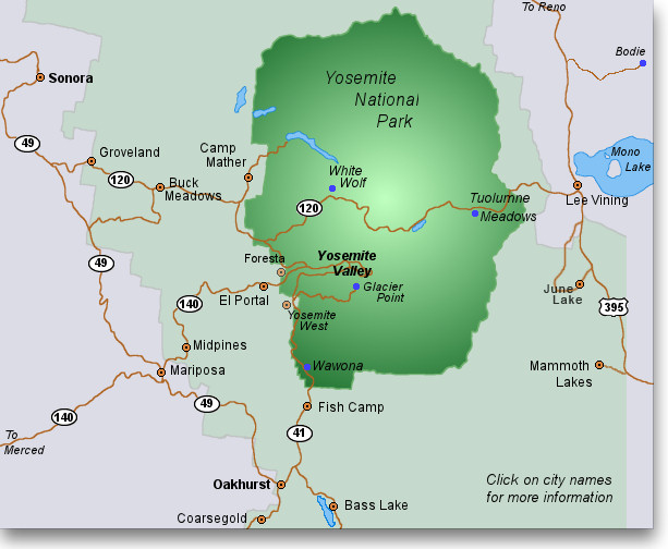
Yosemite Small Map : Large Map