Map of the 4 nights-5 day itinerary (customized layered Map)
🗺️ 5-Day Northern California Road Trip Itinerary
Day 1: June 17 – San Francisco to Mount Shasta
Depart San Francisco early morning.
Stop 1: Sundial Bridge in Redding – a striking pedestrian bridge and functional sundial. (Turtle Bay)
Stop 2: Sacramento River Trail – a scenic 5.6-mile loop, perfect for a light hike. (AllTrails.com)
Stop 3: Shasta Lake – California's largest reservoir, ideal for a picnic or boat rental. (Wikipedia)
Stop 4: Castle Crags State Park – explore granite spires and hiking trails. (California State Parks)
Overnight: Stay in Mount Shasta.(Tripadvisor, AllTrails.com, Visit California, California State Parks)
Day 1: Explore Lake Shasta - On to Mount Shasta
Shasta Lake, located just 15 miles north of Redding, is the state's largest reservoir. It has 370 miles of shoreline and five major lake arms, each with its own distinct character. There is much to explore on the lake, but your destination today is a paddle up the McCloud arm.
On your way to Lake Shasta, stop by the Heritage Roasting Company, a small non-profit coffee roaster/cafe that has a friendly small-town feel and amazing coffee. Grab breakfast for now, and a sandwich for your lunch later in the day, maybe with one of their amazing brownies for dessert?
Pick up your kayak from Holiday Harbor in the morning, and head out onto the McCloud arm of the river. This arm is famous for the grey rocks that rise out of the water. These rocks were formed from ocean sediments many millions of years ago. They make a beautiful picture against the blue-green water of the lake. Padding can be hot work, so feel free to jump into the lake at any point to cool off. Whenever you are hungry, there are plenty of nice coves to pull out of the river, have a picnic lunch, and enjoy a spot of sunbathing. There is no rush to get anywhere today. It is just a day to enjoy the peaceful water, beautiful scenery and fresh air.
Whenever you are ready, paddle back and drop your kayaks back at the marina. Your last stop of the day is to visit the Lake Shasta Caverns. Thought to have formed roughly 250 million years ago, a tour through the caves provides a fascinating view of beautiful stalactite and stalagmite formations. Also, the caverns are at a constant 58 degrees Fahrenheit, no matter the temperature outside, so it is a great way to escape the heat in summer.
After the tour, it's time to head to your hotel in Mt. Shasta. For dinner, try Cafe Maddalena, an elegant Mediterranean restaurant with a small garden for outdoor dining during the summer.
Day 2: June 18 – Mount Shasta to Arcata via Weaverville
Stop 1: Whiskeytown National Recreation Area – enjoy waterfalls, hiking, and lake activities. (National Park Service)
Stop 2: Weaverville – a historic Gold Rush town with unique architecture and museums. (Wikipedia)
Drive: Trinity Scenic Byway (SR 299) – a 130-mile route offering breathtaking views. (AAA)
Overnight: Stay in Arcata.(National Park Service, Wikipedia, AAA, Hotels.com)
As you head out of Eureka this morning, stop in the nearby Beachcomber's Cafe for breakfast, and a to-go lunch. Try their poached egg sandwich, a local favorite. Also, the cafe takes a great stance against disposable cups, so drink your coffee at the cafe, or bring your own cup to take your coffee with you on the road.
Your first stop as you head out of Eureka proper is in Weaverville (103 miles and 2 hrs away). Be aware that the roads can be winding, with a number of hairpin turns, so take your time, and take breaks to enjoy the scenery and lush forests along the way. In Weaverville, stop at the Joss House State Historic Park. The site is a Taoist temple, which is still in use and is the oldest continuously used Chines temple in California. It is an interesting place to learn about the role played by Chinese immigrants in early California history.
The next stop is Whiskytown Lakes (39 miles, 50 minutes). The lake takes its name from the Gold Rush mining town that lies beneath its waters, inundated by the building of the 282-foot Whiskeytown Dam. The lake is known for it's warm, crystal-clear waters- perfect for sunbathing, summer-novel reading, and sandy picnics. The best place to do all of that is at Brandy Cove, where you'll find a sandy beach, shallow water, and all the ingredients you'll need for a relaxing summer afternoon.
After your picnic lunch, if you want a bit more action, head to one of the four waterfalls in the area. Whiskeytown Falls is the tallest with an impressive 220-foot drop. From Hwy-299, turn off at Crystal Creek Road and drive up around 3.5 miles until you reach the James K. Carr trail. From the trailhead, follow the signs for the James K. Carr Trail, as it ascends steadily uphill through a ravine. The trail is 3.4 miles round trip, and the trail is very steep in parts, with over 600 feet of elevation gain, so it is not suitable for young children.
For those with younger children, Brandy Creek Falls is a better option. From Hwy-299, take the turnoff at Kennedy Memorial Drive towards the Whiskeytown Dam. After crossing the dam, follow the paved road that winds around the lake to the Brandy Creek Beach area, and then turn onto Brandy Creek Road. Drive 2.5 miles on the road until you reach the sign for Brandy Creek Falls Trail. The trail is 3 miles round trip and still has modestly steep sections, so watch your step. The waterfall is made up of 5 large cascading falls that sweep down the polished granite rock. From the trail, you will enter a narrow box canyon and see the first of the tiers - Lower Brandy Creek Falls. The Upper Falls is still 0.25 miles ahead. Cross the plank bridges to traverse the creek, and use the footholds chiseled out of the rock and the iron railings to ascend to the upper falls, past five pools and cascades. The upper falls are split in the middle, creating two cascades that flow on either side of the 50-foot-high waterfall. Entering the upper chamber of the waterfall is like being in one of nature's chapels.
After the hike, it's time to head to your hotel in Redding. For dinner tonight, you could splurge with a visit to Clearie's. This high-end eatery is a local favorite for its friendly and cozy atmosphere, as well as amazing cocktails - did someone say smokin' martinis? It will be the perfect end to the perfect day.
Day 3: June 19 – Explore Redwood National and State Parks
Morning: Visit Redwood National and State Parks, home to the world's tallest trees. (Condé Nast Traveler)
Afternoon: Optional trip to Del Norte Coast Redwoods State Park for coastal redwood views.
Evening: Return to Arcata for overnight stay.(Hotels.com)
Full Day: Explore the magnificent Redwood National and State Parks. These parks are cooperatively managed and offer incredible opportunities to walk among the tallest trees on Earth.
Morning: Focus on the central and northern sections of Redwood National and State Parks.
Visitor Centers: Start at a visitor center (e.g., Thomas H. Kuchel Visitor Center near Orick, or the Prairie Creek Redwoods State Park Visitor Center) for maps, current conditions, and ranger advice.
Tall Trees Grove (Permit May Be Required): This grove is home to some of the tallest trees. Check if a permit is required for your visit date as it often is.
Newton B. Drury Parkway & Big Tree Wayside (Prairie Creek Redwoods State Park): A scenic alternative to Highway 101, offering easy access to impressive redwoods and short walks. Keep an eye out for Roosevelt Elk in Elk Prairie.
Afternoon: Consider heading further north to Del Norte Coast Redwoods State Park.
Del Norte Coast Redwoods State Park: Features a mix of old-growth redwoods and dramatic coastline. Trails like Damnation Creek Trail offer a strenuous but rewarding hike down to the beach (check conditions).
Late Afternoon: Drive back to Arcata.
Redwood National and State Parks Official Website: NPS.gov/redw (This is the official NPS site for the combined parks, a good starting point for planning).
Overnight: Arcata, CA
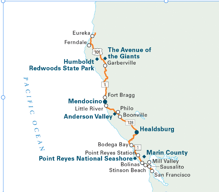
Day 4: June 20 – Arcata to Mendocino via Avenue of the Giants
Drive: Avenue of the Giants – a scenic route through towering redwoods.
Explore: Stop at Humboldt Redwoods State Park for short hikes and photo opportunities.
Overnight: Stay in Mendocino, a charming coastal town.(Condé Nast Traveler)
venue of the Giants & Coastal Drive to Mendocino
Morning: Drive south from Arcata to the Avenue of the Giants.
Driving: Arcata to the northern start of Avenue of the Giants is approximately 45 miles / 45 minutes - 1 hour.
Avenue of the Giants: This 31-mile scenic bypass runs parallel to Highway 101 and offers numerous groves, hiking trails, and roadside attractions where you can stop and walk among giant redwoods. It's part of Humboldt Redwoods State Park.
Founders Grove: An easy loop trail with some of the park's most impressive trees, including the Dyerville Giant.
Immortal Tree: A very old redwood that has survived floods and fires.
Shrine Drive-Thru Tree (Private attraction, fee applies): A classic tourist stop.
Afternoon: Transition from Highway 101 to Highway 1 (the Pacific Coast Highway) as you head towards Mendocino. This section of Highway 1 is incredibly scenic with dramatic coastal cliffs and small towns.
Driving: End of Avenue of the Giants to Mendocino is approximately 100 miles / 2 - 2.5 hours (can be slow due to winding coastal roads).
Evening: Arrive in Mendocino
Mendocino Headlands State Park: Offers beautiful coastal trails and views of the town.
Mendocino Coast Botanical Gardens (near Fort Bragg, just north of Mendocino): A beautiful coastal garden.

Day 5: June 21 – Mendocino to San Francisco
Morning: Enjoy Mendocino's coastal views and local shops.
Drive: Return to San Francisco via Highway 1 or 101.
Arrival: Reach San Francisco Airport by 2:00 PM.
🏨 Recommended Accommodations
Mount Shasta
Arcata
Mendocino
🗺️ Interactive Map
Here's a Google Map outlining your route and key stops:
View Northern California Road Trip Map(AAA)
🌤️ Weather Forecast
Mount Shasta (June 17): Highs around 75°F, lows near 50°F.
Arcata (June 18-19): Highs in the mid-60s°F, lows in the low 50s°F.
Mendocino (June 20): Highs around 65°F, lows near 50°F.(Upstate CA)
Let me know if you'd like assistance with reservations or further details on any part of your trip!
If choose to have one more day at Mendacino
🚃 5. Ride the Skunk Train + Railbikes
In Fort Bragg (~15 min from Mendocino), take a scenic train ride through redwood forests.
Or do the railbikes — pedal-powered carts on the tracks!
🔗 Skunk Train
🍷 6. Wine Tasting in Anderson Valley
Less touristy than Napa, and closer than you think.
Visit Navarro Vineyards, Husch, or Roederer Estate for sparkling wine.
Combine it with a scenic drive down Hwy 128.
🏖️ 7. Relax on Hidden Beaches
Van Damme State Beach, Glass Beach (Fort Bragg), or Bowling Ball Beach near Point Arena.
Beachcombing, tidepooling, and dramatic coastal views.